Two Severe Tropical Cyclones Shaping Weather in the Australian Region
This Tuesday, two severe tropical cyclones are dominating weather patterns in the region, with both Cyclone Maila and Cyclone Vaianu expected to have significant impacts. Cyclone Maila is currently located near Papua New Guinea, while Cyclone Vaianu is situated near Fiji. Both systems are set to influence weather conditions across the Australian region.
Understanding Cyclone Maila
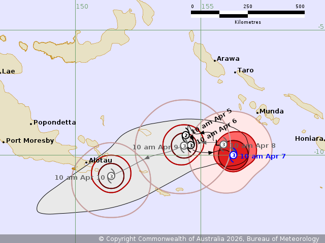
At 10am (AEST) on Tuesday, Cyclone Maila was positioned in the Solomon Sea, between the Solomon Islands and eastern Papua New Guinea. This relatively slow-moving system is classified as a category 3 severe cyclone. It is projected to affect the far southeastern tip of Papua New Guinea by Friday morning. Following this, it is expected to move towards the Far North Queensland coast by the weekend, potentially making landfall over the weekend or early next week.
At this stage, the strength of the cyclone as it approaches the Australian coastline remains uncertain. However, its path suggests that it could bring heavy rainfall and strong winds to the region.
Why Papua New Guinea Rarely Experiences Cyclones
Papua New Guinea typically sees very few cyclones due to its proximity to the equator. The formation of cyclones is influenced by the Coriolis Force, which is responsible for the rotation of air masses. At the equator, the Coriolis Force is zero, and it becomes weak in nearby latitudes. This makes it difficult for low-pressure systems to develop sufficient rotation to become cyclones.
Cyclone Maila formed in waters east of Papua New Guinea, just far enough south to gain cyclonic strength. The PNG Weather Service named the system as it formed within their jurisdiction.
Cyclone Vaianu: A Growing Threat
Tropical Cyclone Vaianu formed near Fiji and was named by the Fiji Meteorological Service. It is currently a category 3 severe tropical cyclone and is causing heavy rain and strong winds as it moves west of Fiji and east of Vanuatu. Importantly, it is not making landfall in either country.
Vaianu is expected to track south during the week, heading towards the North Island of New Zealand. Although it will no longer be a tropical cyclone by the time it reaches the area, it is likely to hit Auckland and nearby regions as an “extratropical cyclone.” These systems can still pack significant strength, comparable to a category 2 or 3 cyclone in terms of central pressure and wind speeds.
The New Zealand Met Service currently has no warnings in place for this system, but this is expected to change as the week progresses.
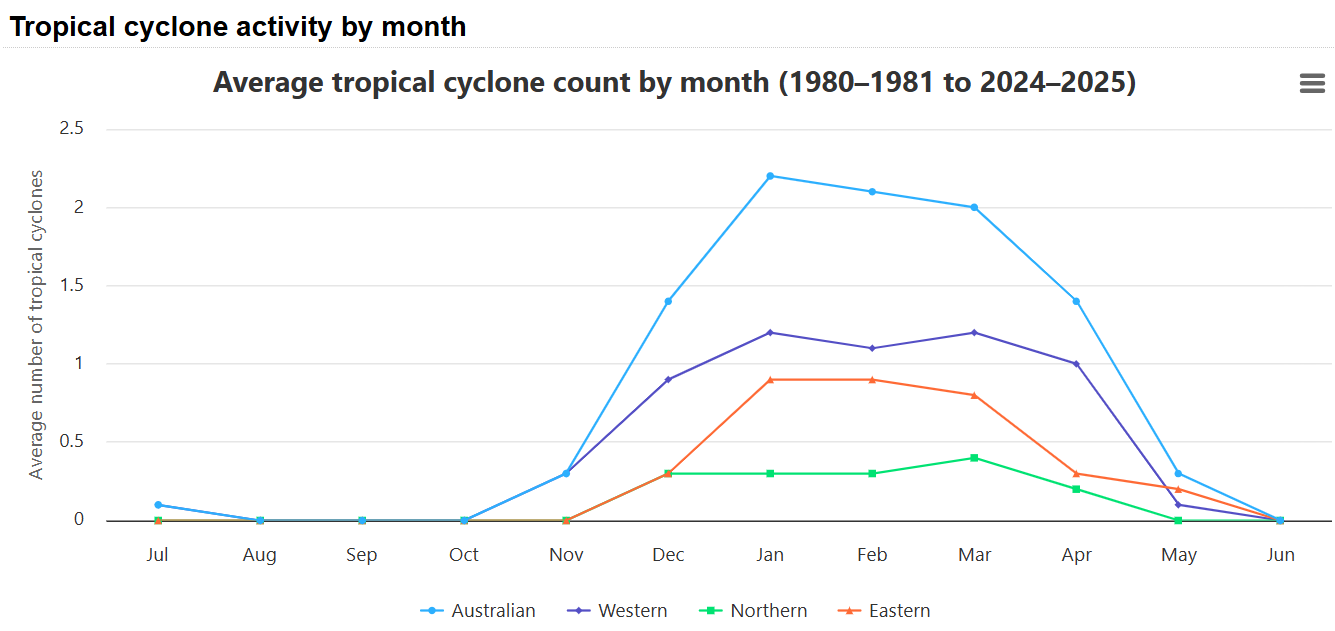
The Rarity of Tropical Cyclones in April
The Australian tropical cyclone season runs from November 1 to April 30. As shown in the graph below, the number of cyclones in the Australian region drops significantly in April, with an average of 1.4 cyclones per year (represented by the light blue line).
Early indications suggest that one or possibly two more cyclones could form in northern Australian waters this week. These are most likely to develop off the Northern Territory and Western Australia. Updates on these developments will be provided as they unfold.


