Revitalizing the Lifelines: A Major Initiative for Sylhet and Habiganj River Basins
For centuries, the Surma and Kushiyara rivers have been the lifeblood of the Sylhet and Habiganj regions. They have sculpted fertile floodplains, enabling agriculture to thrive, but they have also unleashed destructive power with alarming regularity. Each monsoon season brings swollen waters that surge over the banks, devastating farmlands, homes, and vital infrastructure, trapping thousands in a relentless cycle of loss and arduous recovery.
Recognizing the urgent need to break this cycle, the government has launched a significant initiative, a Tk 1,273.77 crore project designed to bolster flood protection, stabilize riverbanks, and implement integrated water resource management within the Surma-Kushiyara river basin. This ambitious undertaking, officially titled the “Surma-Kushiyara River Basin Development and Flood and Integrated Water Resources Management Project (Phase I),” is slated for execution by the Bangladesh Water Development Board under the Ministry of Water Resources. The project’s timeline spans from January 2026 to June 2028, with full financing provided by the government. Its reach will extend across 11 upazilas in the Sylhet and Habiganj districts, areas where agriculture forms the fundamental basis of local livelihoods.
Core Components of the Development Project
At the heart of this comprehensive initiative lies a large-scale river dredging operation. The project aims to dredge over 121 kilometres of river stretches, with an estimated 120.53 million cubic metres of sediment to be meticulously removed. This extensive dredging is crucial for restoring the rivers’ natural carrying capacity and mitigating the risk of overflow.
In addition to dredging, significant riverbank protection works will be undertaken along 17 kilometres of sections that are particularly prone to erosion. These are the areas that have historically suffered the most from the dynamic and often destructive shifting courses of the Surma and Kushiyara.
Understanding the River Systems
The Surma and Kushiyara rivers are integral parts of the vast Ganges-Brahmaputra-Meghna basin. Their journey begins in India as the Barak River before they enter Bangladesh. Upon crossing the border, the river system bifurcates, with one branch flowing through the picturesque, hilly terrain of Sylhet. These two branches eventually converge at Ajmiriganj in Habiganj, forming the Kalni River, which subsequently merges with the Meghna River near Bhairab Bazar. From there, the combined waters eventually find their way to the Bay of Bengal.
The mountainous origins of these rivers dictate their inherent characteristics: they are naturally fast-flowing and highly meandering. This natural dynamism makes erosion a persistent challenge, particularly along the concave bends of the river channels.
Intensifying Challenges and the Need for Action
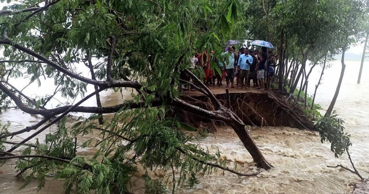
In recent years, the severity of these erosion and flooding issues has been amplified. Climate change, with its propensity for extreme rainfall events, combined with the widespread destruction of upstream hill forests, has led to a dramatic increase in sediment loads entering the rivers. This excess sediment accumulates along the convex bends, effectively constricting the river channels. Consequently, this obstruction accelerates erosion along the opposite banks, a phenomenon detailed in project documents.
During the peak monsoon season, the sheer volume of upstream runoff frequently surpasses the rivers’ capacity to carry the water. This overload inevitably triggers widespread floods, inundating vast expanses of land. The consequences are devastating: crops are destroyed, homes are swept away into the churning waters, and critical public infrastructure, including roads, schools, and religious institutions, endures repeated damage.
The broader river basin encompasses other significant transboundary rivers such as the Sarigoain, Sonai, and Piyain. These rivers originate in India and flow into Bangladesh, eventually merging with the Surma. Severe erosion along these tributaries has already led to the displacement of numerous families and the obliteration of valuable farmland, underscoring the critical urgency for a coordinated and integrated intervention.
A Holistic Approach to Water Management
Officials emphasize that the new project is meticulously designed to address these multifaceted challenges in a truly integrated manner. Key objectives include:
- Maintaining Natural River Flow: Through extensive dredging, the project aims to restore and preserve the natural flow patterns of the rivers.
- Reducing Erosion: Targeted riverbank protection works will significantly curb the ongoing erosion, safeguarding communities and infrastructure.
- Enhancing Fisheries Resources: The improved river health is expected to benefit local fisheries, a vital resource for many communities.
- Protecting Infrastructure: Both public and private infrastructure will receive enhanced protection from the destructive forces of floods and erosion.
A particular focus will be placed on the erosion-prone border stretches within Zakiganj upazila. The riverbank protection works in this sensitive area are anticipated to play a crucial role in safeguarding Bangladesh’s territorial integrity, an aspect often overlooked yet critically important in the context of unchecked river erosion along transboundary waterways.
Long-Term Vision and Community Hope
Upon its successful completion, the project is projected to offer robust protection for crops, homes, roads, mosques, madrasas, orphanages, and other essential installations. This protection will extend across the entire region, shielding them from both the early onset and the peak intensity of monsoon floods.
Beyond the immediate relief from flood and erosion threats, project officials express a strong hope that this initiative will establish a foundational framework for more sustainable water resource management. This, in turn, is expected to foster greater agricultural stability and build long-term socio-economic resilience in one of Bangladesh’s most vulnerable landscapes.
The memory of the devastating monsoon of 2022 remains vivid. Northern and northeastern Bangladesh experienced an unprecedented flood, widely considered the worst in 122 years. This disaster impacted 18 districts, with Sylhet, Sunamganj, Moulvibazar, Habiganj, and Netrakona suffering the most severe damage. The floods claimed 12 lives and profoundly disrupted the lives of approximately 7.2 million people.
Abdul Karim, a resident of Sylhet city, shared his perspective: “If this project can truly control erosion and reduce flooding, it will give people like us some peace of mind. But we hope the work is done properly and finished on time.” His sentiment reflects the widespread anticipation and the earnest hope of the local communities for a tangible and lasting improvement in their lives.


