NSW Braces for Deluge: Severe Thunderstorms and Flash Flooding on the Horizon
Parts of New South Wales are on high alert this week as the Bureau of Meteorology issues stern warnings for intense rainfall, severe thunderstorms, and the very real threat of dangerous flash flooding. The northwest of the state, in particular, is expected to bear the brunt of a significant weather system that has been developing inland.
Senior meteorologist for the Bureau, Dean Narramore, has highlighted the severity of the situation, forecasting widespread rainfall figures that could reach between 100 and 200 millimetres. “This kind of rainfall is going to cause some major flooding and some major issues,” Mr Narramore stated, with these conditions expected to persist until Thursday.
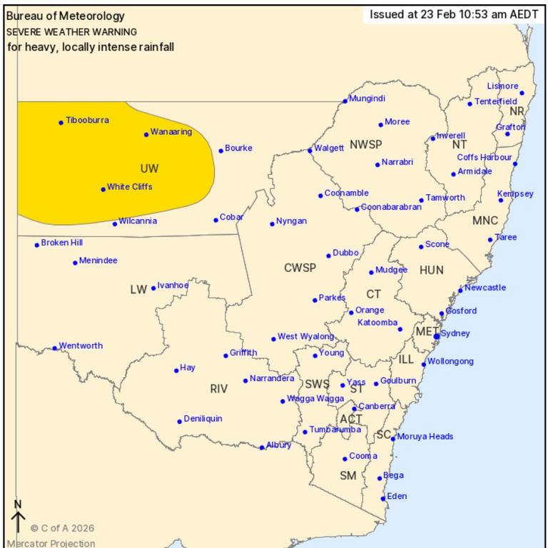
The primary areas facing the most significant impact are located in Northwestern NSW. Towns such as Tibooburra, White Cliffs, Wanaaring, Louth, Tilpa, and Fords Bridge are all in the firing line. The forecast suggests that in some of these locations, rainfall totals could escalate dramatically by the end of the week, potentially reaching an alarming 250 to 300 millimetres. “Higher rainfalls could include 250mm to 300mm at the end of the week … this kind of rainfall is going to cause some big issues,” Mr Narramore cautioned.
The source of this volatile weather is an extreme tropical low-pressure system that has been intensifying since the weekend. Originating from central inland Australia, this system is now interacting with a cold front and an upper trough. This confluence of weather phenomena is responsible for the predicted thunderstorms and heavy rainfall that have already begun impacting various regions of NSW.
Beyond the immediate concerns for the northwest, the Bureau is also forecasting scattered showers and thunderstorms across the eastern and southeastern parts of the state. While these areas may not experience the same intensity as the northwest, rainfall figures of 20 to 30 millimetres are still anticipated in certain locations.
Evidence of the system’s potency was already apparent. By Monday morning, Tibooburra had reportedly accumulated approximately 20 millimetres of rain in just a few hours, demonstrating the rapid onset and intensity of the rainfall.
Looking ahead to the weekend, the outlook for Sydney suggests an increasing likelihood of precipitation. Sky News Weather has predicted a 60 per cent chance of rain by Wednesday, with temperatures expected to range from a low of 22°C to a high of 30°C. The chance of rainfall is forecast to peak over the weekend, with Saturday and Sunday both showing a 70 per cent probability of showers, and maximum temperatures of 27°C and 26°C respectively.
The Bureau of Meteorology has also extended its concern beyond NSW, issuing a Flood Watch for broader regions. This watch encompasses parts of Queensland, South Australia, and the Northern Territory, indicating that the potential for significant rainfall and flooding is a concern across a substantial portion of central and eastern Australia. Residents in all affected areas are strongly advised to stay informed about weather updates and heed any official warnings or evacuation orders.
Key Takeaways for NSW Residents:
- Intense Rainfall Expected: Northwestern NSW is forecast to receive significant rainfall, potentially exceeding 200mm in some areas, with totals reaching up to 300mm by the end of the week.
- Flash Flooding Risk: Dangerous flash flooding is a major concern, particularly in the Upper Western District and areas closer to the South Australian border.
- Widespread Showers: Scattered showers and thunderstorms are also predicted for eastern and southeastern NSW, with rainfall of 20-30mm possible.
- Broader Impact: Flood Watches have been issued for parts of Queensland, South Australia, and the Northern Territory, highlighting a widespread weather event.
- Stay Informed: Residents are urged to monitor official weather warnings and advisories from the Bureau of Meteorology.