Northeast Braces for First Measurable Snowfall of Winter Season
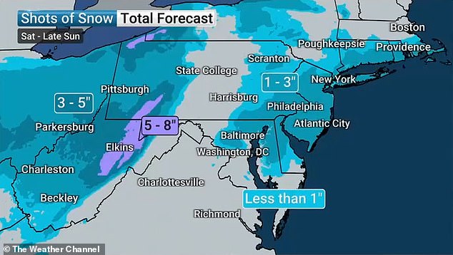
A significant winter storm is poised to sweep across the Northeastern United States beginning Saturday night, bringing with it the season’s first measurable snowfall to major metropolitan areas like New York City and its surrounding regions. Meteorologists are forecasting a range of snow accumulations, with the tri-state area likely to receive between one and three inches.
Areas situated further north, encompassing much of Connecticut, Massachusetts, and Rhode Island, are expected to experience lighter snowfall, with accumulations generally less than one inch. Meanwhile, southern New Jersey, Delaware, and Maryland could see more substantial amounts, potentially ranging from three to five inches.
The initial phase of the storm is predicted to manifest as rain, gradually transitioning westward across the nation. For a large portion of the affected region, Saturday’s temperatures will remain above freezing. However, a significant shift is anticipated by midnight, as forecasters project a sharp drop in temperatures to below freezing. This temperature plunge will signal the change from rain to snow.
The precipitation is expected to commence around 9 p.m. Eastern Time, with the transition to snow anticipated by midnight. The storm’s duration is estimated to be between seven to eight hours, with the system expected to have moved out over the Atlantic Ocean by 10 a.m. on Sunday.
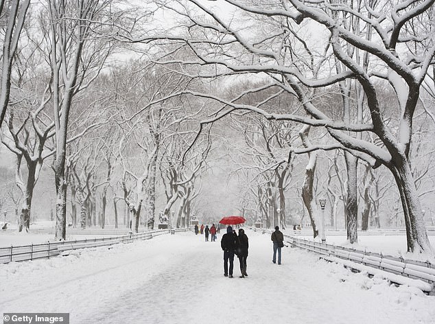
New York City, which typically experiences its first significant snowfall earlier in the season, has issued a weather alert extending through Sunday. City officials are strongly urging residents to exercise caution when traveling on roadways.
Mayor Eric Adams emphasized the city’s preparedness, stating, “The winter season is in full swing, including all the winter weather that comes with it. All New York City agencies are prepared for this system, and we continue to monitor conditions closely.”


The Mayor also advised New Yorkers to take proactive measures: “New Yorkers should all prepare too – avoid driving and give yourself extra travel time with public transit if you do need to travel, stay alert to changing conditions, and sign up for Notify NYC for real-time information updates.”
The National Weather Service has placed New York City under an advisory, effective from 10 p.m. Saturday until 1 p.m. on Sunday. The city itself is projected to receive approximately two to two-and-a-half inches of snow across all five boroughs. Neighboring New Jersey could witness a broader range of accumulations, from one to five inches.
Regarding the potential for higher accumulations, the NWS noted, “While the location of any 5+ inch amounts is less certain, the greatest chance for this is across the I-95 corridor and immediately to the southeast in southern N.J.”
This impending storm follows a period of significant cold experienced across the central and eastern United States during the first two weeks of December.
Travel Advisory Issued for Southern Regions
States south of New Jersey and New York are preparing for a potentially challenging travel day on Sunday. Northern West Virginia and adjacent areas are anticipating considerable snow accumulation, with some National Weather Service alerts indicating potential totals of five to nine inches overnight.
A stark warning has been issued to travelers in these areas: “Persons should consider delaying all travel. If travel is absolutely necessary, drive with extreme caution. Consider taking a winter storm kit along with you, including such items as tire chains, booster cables, flashlight, shovel, blankets and extra clothing.” The advisory further recommended, “Also take water, a first aid kit, and anything else that would help you survive in case you become stranded.”
In other affected regions, Ohio and western Pennsylvania are forecast to receive between four and seven inches of snow. Additionally, lake-effect snow warnings are currently in effect for central and western New York, expected to persist through at least Sunday afternoon.


