
Australia Braces for a Drier, Warmer Autumn
As the vibrant hues of summer begin to fade, Australia is preparing for a significant shift in its seasonal patterns. The Bureau of Meteorology’s latest outlook paints a picture of a markedly drier and warmer autumn across much of the continent for the three months from April to June. This forecast signals a departure from the recent deluge that has seen flash floods and severe thunderstorms batter various regions, though the impending dry spell may spark concerns for agricultural areas as they transition towards winter.
The bureau’s projections indicate that rainfall is likely to fall below average for the majority of Australia during this autumn period. Across vast swathes of the country, there’s a 60% to over 80% probability of experiencing less than typical rainfall. Only the far northern reaches of the continent show a more balanced chance of receiving either above, below, or near-average precipitation.
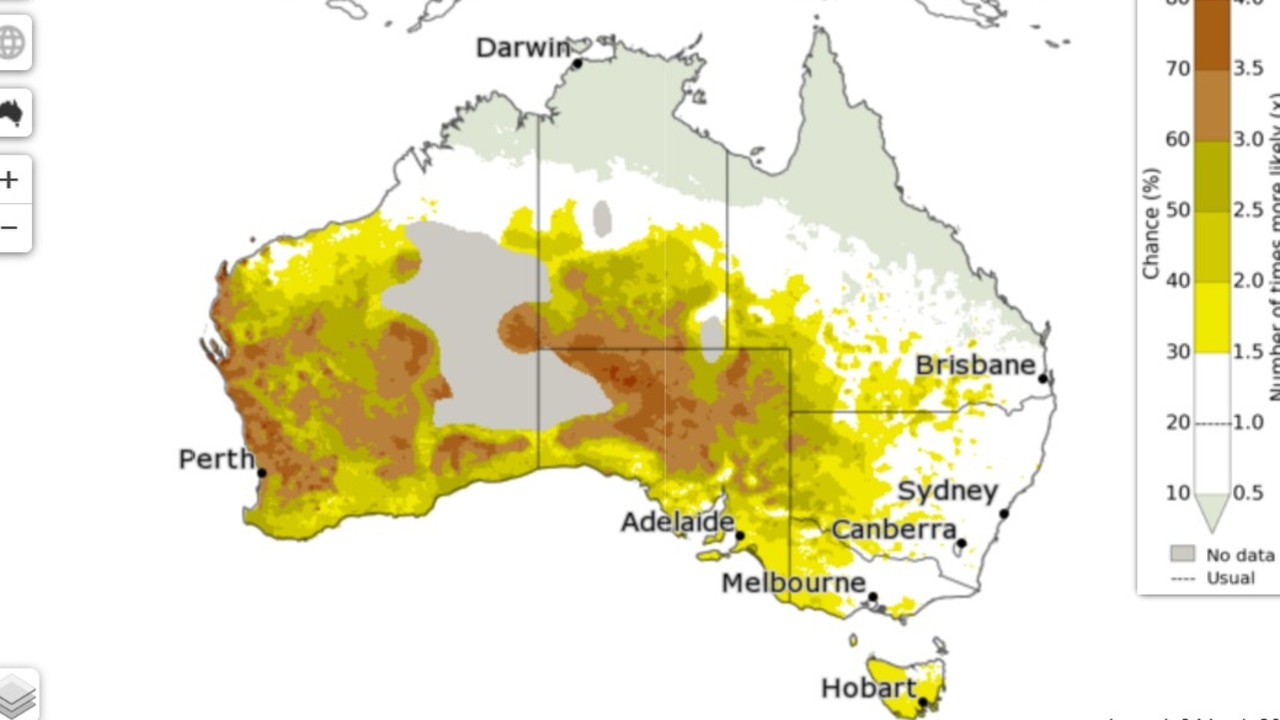
The dry outlook is particularly pronounced for certain regions. Parts of southeastern, eastern, and northern Australia are facing an elevated risk of experiencing unusually low rainfall. This scenario, defined as rainfall totals falling within the driest 20% of records recorded between 1981 and 2018, has a greater than 50% chance of occurring in these areas. The drier conditions are especially significant for May, which traditionally marks the commencement of the dry season in northern Australia. Typically, most of tropical northern Australia receives less than 5mm of rain during May and June. This period offers a crucial window for flood-affected regions to dry out after the above-average rainfall experienced in March.
Rising Temperatures on the Horizon
Accompanying the anticipated decrease in rainfall, maximum temperatures are also expected to trend upwards across most of the southern two-thirds of Australia, along with pockets of the far north. In many of these areas, there’s a more than 80% likelihood that daytime temperatures will be above average.
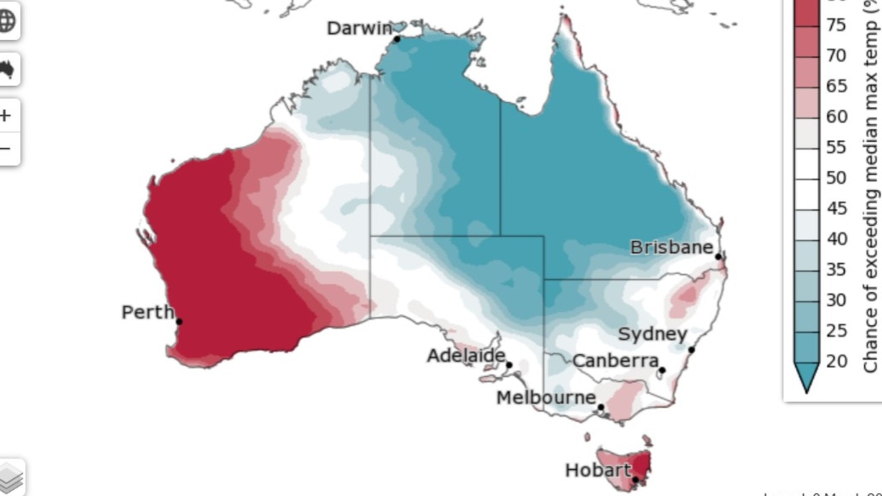
The western reaches of Western Australia and the eastern parts of New South Wales are predicted to experience the most significant likelihood of unusually high maximum temperatures. These regions have a greater than 80% chance of experiencing autumn temperatures that fall within the warmest 20% of historical April to June records.
However, the warmth isn’t a universal forecast. Northern Queensland and the Northern Territory present a more nuanced picture regarding high temperatures. These areas have a roughly equal probability of experiencing above or below-average high temperatures, with some locations showing a 60% to 75% chance of warmer conditions.
A Mixed Bag for Overnight Temperatures
The outlook for overnight low temperatures offers a more varied outlook. While above-average temperatures are likely across a substantial portion of Western Australia and along the eastern and southern coastlines, there isn’t a clear predictive signal for most of Australia’s inland areas.

Despite this general uncertainty, certain areas are identified as having an increased chance of experiencing unusually warm nights. These include parts of southwestern Australia and coastal regions along the Central Coast of New South Wales.
Near-Term Weather Patterns
Looking at the immediate future, the Bureau of Meteorology forecasts above-average rainfall for most of Australia during the second week of March. The exceptions to this are anticipated in parts of southern Australia. As March progresses into its latter half, the trend is expected to continue with above-average rainfall likely over much of the tropical north. Conversely, below-average rainfall is predicted for certain areas within South Australia.


